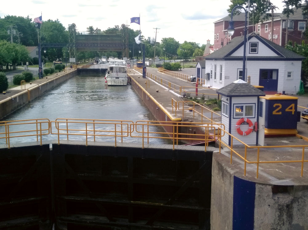
Outward bound from Baldwinsville, N.Y., headed west, looking out over Lock 24. Photo by Dick Allen
By Capt. Dick Allen
For Points East
Calm water, pleasant scenery, affordable or free dockage, and all those picturesque waterfront villages: What more could a cruising couple ask for? All of these and more attracted my wife Bev and me to the New York State Canal System in 2005. Back then, we delivered the 50-foot pontoon boat Night Heron from Snug Harbor, R.I., to Alexandria Bay, N.Y., in the Thousand Islands region of the Saint Lawrence River.
Twelve years later, we retraced our route down Long Island Sound to New York City, up the Hudson River to the Erie Canal, across the Oswego Canal to Oswego, N.Y., and across Lake Ontario to the Saint Lawrence River. On that cruise, we extended our route to Ottawa and Montreal via the hand-operated locks of the Rideau Canal and the Ottawa River, returning to the Hudson River along the Saint Lawrence Seaway and across Lake Champlain. I recounted that trip in the two-part “Busman’s Holiday” articles in the December 2018 and January 2019 issues of Points East.
Last year, aboard our 32-foot Seaquest trawler, Weak Moment, we headed back to the Erie Canal, this time to explore the western half of the canal. This would be beyond the junction with the Oswego Canal, the western extent of our previous cruise.
We started in Westerly, R.I., on June 25, traveling known waters until July 6, when we entered new cruising territory. This was at Three Rivers – the convergence of the Oswego, Oneida and Seneca rivers – about halfway across the Erie Canal. By 1 p.m., we were secured to the free, floating docks west of Lock 24 in Baldwinsville, N.Y., on the Seneca River.
Baldwinsville provides free water and electric, and is one of the more popular spots we visited on the Erie Canal. By 9 p.m., 15 boats were along the wall. Restaurants and some provisions are available within walking distance from the docks, and supermarkets are a long walk or a short Uber ride. The neighbors in Baldwinsville tend to be quiet: A cemetery borders the lock wall for most of its length. But I swear those tombstones were rocking when the band warmed up for a concert at the Bud Light Amphitheater across the canal on Paper Mill Island.
The morning of July 7 saw the temperature dip to 49 degrees at dawn, cloaking the canal in sea smoke as we prepared to get under way at 8 a.m. Great blue herons often escorted us along the canal, taking flight as we approached, flying ahead for a short distance, then lighting again until we caught up. Kingfishers flitted back and forth across the canal, and little green herons worked the underbrush.
We enjoyed another free tie-up that night at Lock 25, in Mays Point, near the junction of the Seneca and Clyde rivers, and another on July 8 in Palmyra, N.Y., which also provides restrooms and showers. The small museum near the docks, and many interpretive signs in the village of Palmyra, started to give us a sense of the interesting people and events that the Erie Canal brought to upstate New York in the mid-1800s. A bucolic trail runs about one mile from the docks along the original route of the Erie Canal to Aqueduct Park, where some of the old canal structures can still be seen. Lunch at Nima’s Pizza was good and reasonable.
On July 9, we docked at Fairport, N.Y., for $14 per night, with water, electric and clean restrooms and showers. Fairport – the most prosperous looking town we encountered along the canal – lives up to its label as the “Crown Jewel of the Erie Canal.” Fairport, a suburb of Rochester, was named as one of the “Best Places to Live” by the now-defunct “Money” magazine in 2005. Ice is available in the nearby tour-boat office, and a Dollar Tree, ice cream shops, and restaurants are a short walk away.
July 10 took us through the “Rock Cut,” where the canal was cut out of solid rock and the sides go straight up. A five-hour day brought us to Spencerport, where docking is free and the canal-side Depot & Canal Museum provides restrooms and showers for donations. A supermarket and restaurants are within a block or two of the docks.
From Spencerport to Medina, the canal is often above the surrounding land. It seems odd to be looking down at homes and yards as one cruises by. At one point a state highway passes under the canal just east of Medina, where we stopped on July 11. Medina provided showers and restrooms, but the contractor who built the facilities put the floor drains at a high point, meaning that there was standing water in the restroom – ugh!
Our original plan had been to cruise to Tonawanda at the west end of the Erie Canal. However, when we learned that the Tonawanda Canal Fest had boats rafted eight deep – and the sobriety of boaters approaching Tonawanda would be questionable – we elected to turn around at Medina and head east again after using the free, self-service pump-out.
The afternoon of July 12 found us in Brockport, N.Y., where dockage was $12 for the night and the visitors’ center provided restrooms, showers, a laundry, and free use of bicycles. Walmart and Lowe’s are both a mile and a half from the dock, an easy circular bike ride. Rite Aid and Dollar General are a short walk. We enjoyed another free concert on the dock.
Four hours east of Brockport is Pittsford, with free dockage including water, electric, a volunteer welcoming committee, and free concerts on Friday evenings. Ice and ice cream can be acquired within walking distance.
Newark, N.Y., was our next stop, and I considered their restroom, shower and free laundry facilities the best on the New York State Canal System. Dockage with water and electric is free on long walls on both sides of the canal, and the murals on the visitors’ center and bridge abutment were the best we’d seen. Newark was a great stop, with nearby restaurants and a supermarket – and more to come judging by the building restoration next to the waterfront park.
We were welcomed to the Lauraville Landing free dock in Clyde, with a band concert in the gazebo. Sadly, the local community group that put on the event didn’t get much of a turnout. The Lauraville Landing Park is isolated from the rest of Clyde, but a pleasant path provided a nice walk through the woods.
On July 16, Weak Moment turned south off the Erie Canal into the Cayuga-Seneca (CS) Canal, leading to Cayuga and Seneca lakes, two of the largest Finger Lakes. Our destination was Watkins Glen, at the south end of Seneca Lake, so we turned west on the CS toward Seneca Falls after passing through Lock CS1 in Cayuga. On another cruise we might continue south to Cayuga Lake.
Seneca Falls is another pleasant, tree-lined free dock with restrooms, showers and a laundry room in a waterfront visitors’ center. Seneca Falls might be called the “Museum City.” The building above the boaters’ visitor center houses a remarkable Museum of Waterways and Industry. The museum depicts the building of the Cayuga-Seneca Canal and the industries it spawned, including leading inventors and builders of pumps, fire hydrants, flat irons, the trademark Seneca Knitting Mills “Red Top” hunting socks, and electronics such as Sylvania. This industrial development is credited with providing the affluence that allowed the local citizens to become leaders in such social issues as women’s rights and abolition.
The first women’s rights convention was held in Seneca Falls in 1848. Trip Advisor rates the Women’s Rights National Historical Park as the No. 1 museum in Seneca Falls, followed by the “It’s a Wonderful Life Museum,” celebrating the movie of the same name, the National Women’s Hall of Fame, and the Seneca Museum of Waterways and Industry. The Center for Great Women of the National Women’s Hall of Fame will soon make its home in the former Seneca Knitting Mills factory, a landmark on the south bank of the CS Canal. All of the museums in Seneca Falls are within walking distance of the docks.
We enjoyed dinner with our boating neighbors at Parker’s Grille & Tap House, which served a very good, hot-buttered lobster roll for $14.99.
On July 17, after clearing Lock CS 4 in Waterloo at 10:20 a.m., we made a six-and-a-half-hour run down Seneca Lake and docked at the Watkins Glen Yacht Club. Seneca Lake provided a real change in scenery, with vineyard-laden hills rising on both sides. Seneca Lake is the deepest freshwater lake east of the Mississippi River, outside of the Great Lakes, and features over 600-foot soundings in places. Surprisingly, in these bucolic surroundings, two large barges with towering cranes were anchored in the middle of the lake. This was the Seneca Lake U.S. Navy Sonar Test Facility. Some strange images appeared on my color-video depth sounder, and I wondered if they were related to sonar testing.
Watkins Glen was a highlight of our trip, thanks to the members of the Watkins Glen Yacht Club. The dockmaster and his helpers made us more than welcome at their fine facility. Other than the automobile racetrack, the major attraction in Watkins Glen is hiking the Gorge. Luckily, yacht club members offered an energy-saving tip: Take the shuttle bus up and hike down. The scenery was spectacular.
Also in Watkins Glen is the Cargill Salt Refinery, processing salt mined from deposits under Seneca Lake. U.S. Salt also operates a refinery in Watkins Glen, using salt brought to the surface from a 1,500-foot deep well.
We were back in Seneca Falls on July 19 in time to enjoy another free concert in the waterfront park.
July 20 brought us back to Baldwinsville, where more than 500 feet of floating dock and lock wall were jammed with boats in town to hear the concert at the Bud Light Amphitheater. On July 21, after 15 easy and enjoyable cruising days – we were at Ess-Kay Yards in Brewerton, at the west end of Oneida Lake, just north of Syracuse. We didn’t make it to Tonawanda, but there’s always next year. So I guess we can finish the verse from that old barge song now, and believe me when I sing:
“You’ll always know your neighbor,
And you’ll always know your pal,
If ya ever navigated on the Erie Canal.”
Erie Canal cruising tidbits

Bev with a box hook used to grab ladders and pipes and a simple line, tied amidships around a pipe, that allowed Weak Moment to rise with the water in the lock.
East or west: We enjoy the entire New York State Canal System, but we found the western portion of the Erie Canal more inviting than the eastern half, with more historically noteworthy waterfront towns, and a greater variety of scenery.
Boating traffic: This isn’t a problem anywhere on the canal, but there may be slightly fewer boats on the western half because the bridge clearance is only 15.62 feet at road bridge E-123 in Wayneport, N.Y., about 75 miles west of Brewerton. Boats with up to 21 feet of air draft can transit the eastern half of the Erie Canal and the Oswego Canal to reach Lake Ontario and the cruising routes beyond.
Canal depths: They aren’t a problem for boats drawing less than seven feet, but the deepest water may not always be in the middle of the channel. The New York State Canal Corporation provides detailed depth information on its website (www.canals.ny.gov/navinfo/index.html).
Distances: The entire Erie Canal is about 340 miles from Lock E-2, in Waterford, N.Y., to the Niagara River in Tonawanda, N.Y. We explored the first 160 miles on earlier trips, so last year, we set out to see the remaining 180 miles, plus a 100-mile side trip down Seneca Lake to Watkins Glen, N.Y.
Docking and amenities: There are 34 locks on the Erie Canal between Waterford and Tonawanda. Free overnight docking is available along most of the lock walls at either end of the lock. Many villages along the canal provide free or low-cost docking, often with water, electric, restrooms, showers and, sometimes, laundry rooms.
Lock transit: Passage through locks is relatively easy once you learn the ropes – literally: Erie Canal locks have ropes hanging down from the tops of the lock walls. Most cruisers use these to hold their boats against the lock wall, one line at the bow and one at the stern.
However, the locks also have vinyl-coated cables running from top to bottom, or five-inch-diameter pipes recessed in the lock walls, or steel ladders, also recessed into the lock walls at each end of the lock. Bev and I found it much easier to pass a single amidships line around a cable or pipe, and fasten it back at the boat. If no cables or pipes were available, we used a box hook to grab the rung of a ladder, moving the hook up or down a few rungs as the water level changed. Having a pilothouse door next to the lower helm helped immeasurably in working the locks.
Rigging fenders: Good fenders are a necessity, placed forward, aft and amidships to protect your hull and rails. Rigging fenders on both sides avoids a fire drill upon arrival at a lock where you must tie up on the side opposite where your fenders are hung. Generally, the guidebooks and the lockmaster will tell you, in advance, the side of the lock to use.
Know your neighbors: All sizes of boats ply the New York State Canal System, from canoes and kayaks to 60-foot motor yachts. Trailerable boats can access the canals at numerous launching ramps, but larger boats will travel up the Hudson River to reach the entrance to the Erie Canal at Waterford, N.Y., if coming from the Atlantic Coast. The Hudson is tidal all the way to the Federal Lock in Troy, N.Y., and oceangoing ships use the port of Albany.
Capt. Dick Allen’s boating career includes service on landing craft in Vietnam, on the first offshore lobster trap-fishing boat, and on the last Lampara herring seiner in San Francisco Bay. He operated inshore and offshore lobsterboats, ran the glass-bottom nature-cruise boat Night Heron on Point Judith Pond, and skippered the pilot boat Olympic out of Snug Harbor, R.I. He has plied the Intracoastal Waterway often.


 We have complete issues archived to 2009. You can read them for free by following this link.