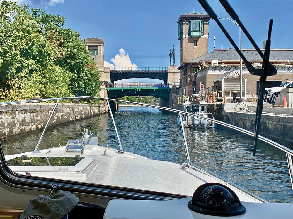
Traveling through the Craigie Canal heading for the drawbridge. Photo by Rand Peck
September 2023
By Rand Peck
For several years I’d wanted to cruise up the Charles River, but my background as an airline pilot demanded I do so armed with critical information. I knew I would be ill-advised to just set a course and see what happens. I crafted this little guide so others who wish to see the Charles River, Boston and Cambridge can do so armed with all the necessary knowledge.
As I tackled this exercise, I realized that I had no idea how to access the locks, how many bridges there were, and how, if necessary, to contact their operators. I did not know the water depths, the local obstacles, speed limits, the nature of university boat traffic, and the clearances of the fixed bridges (e.g., the Harvard and Longfellow bridges). I learned ahead of time that I would have no bridge issues, but that I’d need to lower my VHF antenna and use my handheld unit if necessary.
With some effort, I acquired all of this intelligence – including how to speak with the bridge authority – over the phone. This last was the most useful, as I learned that the commuter-rail bridge near North Station closes to boat traffic twice a day for two and a half hours or so. If you time your passage poorly, you could sit in Boston Inner Harbor or the Charles River Basin for 2.5 hours to get from one side to the other.
So it was time for my wife Linda and me to depart for Boston on a one-day trip out and back from Beverly. According to my notes, it was 42 miles from my homeport of Beverly, Mass., to “Old Ironsides,” at the mouth of the Charles in Boston Inner Harbor. If I had optimal seas and cruised at 25 mph, I mused, I could cover this in an hour and three-quarters. But that would be without stopping to take photos.
I purposely swung by a variety of historical spots: Boston Light, the Boston Tea Party Ships and Museum, the Old North Church, the USS Constitution (“Old Ironsides”) and Bunker Hill to let readers know that there are more reasons to explore Boston Harbor than to enter the Charles River, and they are all easily accessible.
Armed with information, my shortcomings in this new environment were minimized, and the experience would be more enjoyable. From entering the lock to turning around between the Harvard and Boston University bridges took us a little over an hour.
I approach every trip I take into unknown waters with my own “flight plan,” with points enroute, headings and distances to and from in case of a chartplotter failure – backed up with a paper chart close at hand. I’m not a rookie regarding boat handling, but I am concerning ocean boating. I am well aware of this and plan for the worst. I carry a four-man, self-inflatable life raft, with a bug-out bag, and have no alcohol on board. But I do enjoy a beer or two back on the Jubilee Yacht Club deck with friends. Here’s how this day unfolded for us, step by step:
Aug. 25, 2022: Jubilee Yacht Club, Beverly (Mass.) Harbor, to Col. Richard Gridley Locks (named for Gen. George Washington’s first Army engineer) and the Charles River drawbridges. After reading everything I could find and watching a YouTube video, I called the control center (617-727-0488) associated with the locks and the drawbridges. I had many questions, and the fellow with whom I spoke cheerfully answered them all. Some might consider this overkill. But, with no experience here, I didn’t want to be the one to gum up the works and find myself on the front page of the “Boston Globe.” I could visualize the headline: “Recreational boater from New Hampshire….”
We departed Beverly at 8:15 and passed such historic sites as Graves Light, Boston Light, Fort Independence, the Old North Church, the Boston Tea Party, Bunker Hill Monument and “Old Ironsides” (the USS Constitution, the nation’s oldest commissioned warship) to be at the lock by 10 a.m. The span following the lock, the MBTA train bridge, remains closed from 6 a.m. to 9:30 a.m., for morning commuter-train traffic – something I learned from my phone conversation.
Approaching the Gridley Locks, I sounded two longs and two shorts on my foghorn. Moments later, an iron door opened, the traffic light changed to green, and we proceeded into the lock, leaving room for others behind us. Linda grabbed hold of one of the strategically positioned ropes. A few minutes later, the door in front of us opened, the light turned green, and off we went. There are three parallel locks: The largest is 300 feet long and 40 feet wide; the smaller two are 200 by 25 feet. Our lock was pretty straightforward, no surprises.
We were now beneath the Route I-93/U.S. 1 Leonard P. Zakim Bunker Hill Memorial Bridge, abeam North Station and the Old Boston Garden. With a slight turn to starboard, I followed beneath the Zakim for a hundred yards toward the MBTA train drawbridge. A non-mariner might be wondering how I knew if I had sufficient depth. Well, my chartplotter indicated 22.5 feet, and nowhere along this cruise were depths or obstacles a concern.
Approaching the closed MBTA bridge, I called on Channel 13, stating I was on the east side and standing by. A voice I recognized from my phone call days earlier acknowledged, advising that he’d open again in about 10 minutes. Boats started to line up behind us, while many trains, whistles blowing and bells clanging, crossed the bridge. I thoroughly enjoyed this foreign environment. We waited nearly 20 minutes before the bridge raised and two-way traffic started. With no current or wind, remaining in place was not difficult. No surprises here, either.
Now we were in the Charles River Basin, by the Museum of Science, where the Duck Boats arrive and depart from their own designated ramp. Keep an eye out for them: They are everywhere.
A Duck Boat, in military jargon, is a DUKW, which, to General Motors, was a designation that indicated production year (D, 1942), U (utility vehicle), K (front-wheel drive) and W (tandem rear axles). It was a six-wheel, amphibious vehicle designed by yacht designers Sparkman and Stephens to carry 24 troops, and 21,147 were built. I probably saw a dozen of them this day.
Straight ahead, maybe 200 yards off, was the Craigie Drawbridge – also known as the Charles River Dam Bridge – which advertised 15 feet of clearance. If you need more, call them on Channel 13. I had no issues as I’d already lowered my VHF antenna and mooring light.
After passing beneath the bridge, you’ll be in the cement-lined Craigie Channel for 50 yards before finally arriving into the Charles River. This was one-way traffic with no traffic lights for guidance. Once again, no surprises.
Entering the Charles River – Boston (founded in 1630) to port and Cambridge (created as a town 1631) to starboard – you’re likely to see many collegiate rowing sculls and shells and gaggles of tiny white sailboats. Sculls and shells have scant freeboard, thus boats’ wakes are a serious concern.
Directly over your bow, you’ll see the beautiful, 1,767-foot Cambridge Street Bridge, opened for traffic in 1906 and renamed the Longfellow Bridge in 1927, after Henry Wadsworth Longfellow. The central piers feature granite carvings of Viking war vessels supporting the seals of Boston and Cambridge. The bridge earned the name “salt and pepper shaker” due to the shape of these ornate towers. Remember, keep to the center.
Next we approached the Harvard Bridge, aka the MIT Bridge, with the ever-recognizable CITGO sign near Kenmore Square in the background. This sign was built in 1965 to replace an older Cities Service sign from the 1940s and slated for demolition in 1982. But it was too famous due to its visibility from Fenway Park, the oldest major league baseball stadium in America. Fenway opened just five days after the Titanic sank in April 1912. The outcry about the sign was so great that it now has a special exemption and lives on as yet another iconic Boston landmark. But compared to the Longfellow, Harvard Bridge has no uniqueness other than it supports the major thoroughfare of Massachusetts Avenue and is decorated with the enigmatic calibrations along the sidewalk called “Smoots” (Google Oliver “Ollie” Smoot).
And finally, before we turned around just past the Harvard Bridge, while looking at the BU Bridge, we took the time to simply stop and enjoy the bigger picture. I went to high school in Downtown Boston and crossed the Harvard Bridge from Memorial Drive to Mass Avenue to Huntington Avenue every day. But I never took the time to enjoy the Charles River or any of the other historical or significant buildings or sites. After a proper respite to take it all in, we headed downriver. A pleasant and useful video of the leg back to Boston Harbor, via the bridges and locks, can be found at www.youtube.com/watch?v=7Q51UsfLZ80.
I was glad I’d done my research, and there were no surprises – and very little traffic for a Thursday morning. The commuter-rail bridge that serves rail traffic toward Cape Ann remains closed in the mornings from 0600 to 0930 and in the afternoon from 1600 until 1830 for heavy commuter rail traffic. Plan your trip accordingly. I did, and our day’s exploration was a complete success. I’ll be repeating this rich experience in the future, but with passengers or other boats in tow.
Amherst, N.H., resident Rand Peck was a commercial pilot between 1974 and 2012. His career began with Air New England and ended with Delta Air Lines. Since his retirement in 2012, his life has centered around his family and cruising D-Sea-10, a 27-foot Eastern Boat Works Downeast cruiser, in New England waters, his camera always within reach.


 We have complete issues archived to 2009. You can read them for free by following this link.