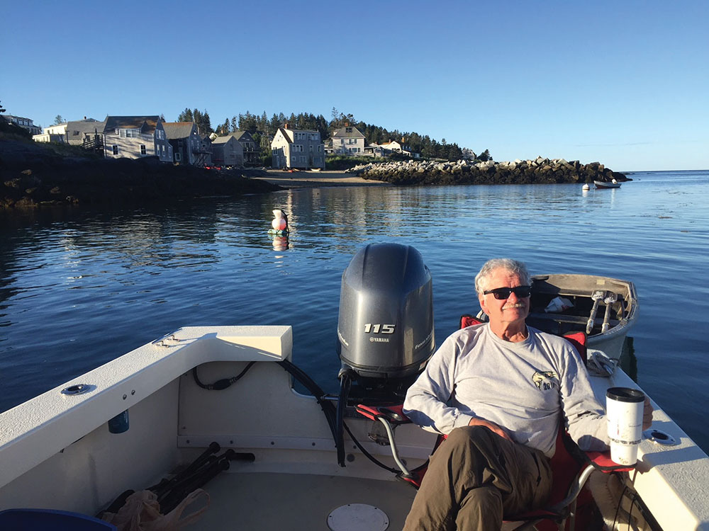
Crewmate Uncle Ron relaxes with his morning coffee at anchor on Monhegan Island. Photo by Kevin McCarthy
Fall 2023
By Kevin McCarthy
I had been eyeing Maine’s offshore islands – Monhegan and Matinicus – for years, but most of my small-craft adventures weren’t conducive to traveling 12 to 20 miles from safe harbor. However, working as the manufacturers rep for three boat companies always gave me a number of vessel options.
I imagined a small vessel that enabled overnight cruising, with a shallow draft for gunkholing. I wanted a craft robust enough to handle exposed conditions, yet trailerable so I could launch from Portland, Maine, rather than from our Piscataqua River, N.H., home port. “Sailing” downwind on I-95 would save me the day-and-a-half slog from the Granite State to Cape Elizabeth. The 22-foot Sisu sitting behind the shop I worked for at the time seemed to be what I was looking for. Its huge V-berth could sleep two, the lobster-style hardtop afforded ample weather protection, and that it was sitting on a trailer sealed the deal.
Almost as important as the vessel is the choice of crew. My plan called for a roll-with-the-punches kind of guy, and I went with a proven player, my uncle, Ron Maher. Ron’s more of a lakes and mountains man, but we’d logged untold miles in both pleasant and adverse conditions, and I trusted his easy, steady demeanor.
After a July 4 shakedown cruise to the Isles of Shoals, we set out for our launch site, Bug Light Park in South Portland. Under way at 9:32, we were greeted by the fresh breeze and confused chop not uncommon in a big commercial harbor. We both appreciated the weather protection of the hardtop.
Within the first hour, we ducked in behind Chebeague Island and grabbed a mooring ball. Two men in a small boat need to get organized beyond stowing bags and prioritizing equipment; that first stop gave us the opportunity to mentally shift gears from land to sea. An improvised chart table was established forward of the mate’s seat – ample water at hand, sunscreen to slather. And extra layers of clothes: Layering up and down would be a step we’d repeat often.
Rather than head offshore right away, I wanted to get Ron on Eagle Island, Adm. Robert E. Peary’s (of Arctic fame) summer home, now preserved as a museum. I knew he could appreciate Perry’s eye for his surroundings, evident in his taxidermy work and pictures adorning the walls. Both Ron and I were in awe of the resourcefulness required of the first man to set foot on the North Pole.
Back aboard we took a one-step-at-a-time approach that saw the 74-foot monument – a daybeacon structure and lifesaving facility – on Little Mark Island off our stern as we steered the 7.9 miles to Cape Small. This, we agreed, would be a good point to decide whether to draw a rhumb line for Monhegan or stay closer to shore while continuing east. We also started our rotating 30-minute watch at the wheel, a schedule we continued throughout the trip.
I was struck by the utilitarian nature of our craft. Our personal effects stayed dry in the cavernous V-berth, and we had two pedestal seats, which slid forward for comfortable seating, and moved back for a desirable leaning-post position, something we’d appreciate as conditions got sporty. The cockpit was simple and functional, with plenty of room for securing our two coolers, a large plastic box holding our dry goods, and additional ground tackle to the gunwales.
Soon Cape Small was off our port beam. The forecast called for the high-pressure system to remain. Three-foot seas didn’t alarm my lake-minded mate, and it was time to head 98 degrees for the roughly 25-mile run to Monhegan Island. Quickly, I found the sweet spot for our craft in the current sea state: 12 mph provided a comfortable ride in which the bow, rising and falling, could wander 10 to 15 degrees side-to-side and still stay on-course with little correction.
Wide-open-throttle with the Yamaha 115 could get us up into the mid-30s, but we were shooting for a comfortable speed that allowed the hull to get in sync with the sea state. We wanted to avoid pounding, and to allow the boat’s hull form to do the thing it was designed to do. Often that means backing off the throttle a bit. However, the reward is often a soft, predictable ride.
Ron and I proved to be a good navigating team. Despite redundant GPS systems, our go-to tool was a compass with chartwork. We would dead-reckon using speed, distance and time, then verify our position with the chartplotter. This is the method I used long before $300 could buy you a handheld GPS, and it still gives me great pleasure. I find it adds to my sense of adventure, and I get satisfaction out of its accuracy. I prefer to use GPS as a backup on a trip like this, rather than the primary navigation tool.
Several hours later, the dot on the horizon had features: lighthouse, houses, tower. We eased into the somewhat protected harbor with minimal fanfare. Not the most inviting harbor for access; no dock except the tour-boat wharf, from which a few day-trippers were embarking. The harbor had a big, bold feel that didn’t encourage anchoring close to shore. After relaxing and taking in our scene, I called across to the only other cruising vessel in the harbor; a family was moored in their 40-foot sailboat. They said they rowed ashore to pay the mooring fee, and pointed to where I could find Sherm, the harbormaster.
So, without a dinghy, how do we get ashore? If this had been my boat, I would have mounted Thule-style kayak racks on the aft-end of the roof and carried those minimalist dinghies. If we’d had harbor-cruise plans, towing an eight-foot dink would have been an option. I’d bought an inflatable dinghy that Ron later said was better for a children’s swimming pool. Not wanting to dig that out, I had Ron put the bow on the beach so I could scout out the situation.
As soon as I touched land I felt warmer, and when I met Sherm I felt even more comfortable. Harbormaster Sherm was a pleasant man with an easy way about him. He welcomed me to the island, admired my vessel, donated a mooring, and even lent me his wooden skiff with which to come and go.
Once settled on our mooring, we rowed in search of a good meal. The Island Inn, which was visible from the water, seemed inviting. We were seated overlooking the harbor, with a view across to an abandoned farm on nearby Manana Island. Ron graciously treated me to my birthday meal as I watched another year sail by. After a delicious dinner, we went for a hike. Monhegan has a fine network of trails to explore, highlighted by bold headlands shaped and battered by the sea.
Our first overnight was uneventful. Thursday morning, my backpack stove boiled water for what trendy shops call a pour-over – truly the way to start the day. And that day had us under way at 7:30 a.m., heading toward Matinicus. Right there in the distance, our next island seemed easy enough to reach. According to the GPS, we were a little off-course, but not to worry, right? Well, soon we realized that our visual was Metinic Island, not Matinicus, which was still just a dot 18-plus miles on the horizon. We agreed that another day of open-water cruising wasn’t the best choice for our trip, and we changed course for a closer inspection of Metinic and an afternoon savored in Rockland Harbor.
The cruise took on a different feel. Rather than being miles offshore, we started to pass more interesting features as we made our way up Penobscot Bay. Pleasant, Hewett and Andrews islands played out to port. Owls Head soon gave way to bustling Rockland Harbor, where our first order of business was to top off with fuel. I was pleased to only need 18.3 gallons after so many hours under way. With a 60-gallon capacity, it was comforting to know that this boat had long legs.
In town, I was reminded of how much I liked Rockland. It’s now an artsy little boating community, with a great choice of restaurants, coffee shops and music venues, all of which have added to the seaport city’s remarkable resurgence. It would have been easy to stay longer, what with the North Atlantic Blues Festival coming to town, but this was a cruising trip, so we got under way.
We ducked inside of Monroe Island, heading south-southwest in Owls Head Bay for a more protected run down Muscle Ridge Channel. We made 17.5 mph, our fastest speed yet, and we were clearly in a groove, with downtime spent piloting from the rooftop or lounging in a deck chair. To further break up the time, we took a break in the protection of Muscongus Bay’s Harbor Island. Ron and I were entertained by the young mate from a tour boat rowing passengers to the island aboard a traditional dory.
My first thought was to go to Robinhood Cove and drop anchor for the night, but, as we approached Boothbay, a new plan emerged. After a brief recon, we tied up at the Tugboat Inn Marina, in the front row, as we referred to our berth for the night. Any ideas that we would rough it went out the window as we treated ourselves to a hot shower, another fantastic meal, and a double-dip waffle cone for dessert. Life was good on the high seas.
Friday was to be a different kind of day. After coffee, we started the river leg of our journey, passing over the top of Southport Island, running across the Sheepscot River, up the Sasanoa River, then down the mighty Kennebec. Fort Popham signaled our gateway back into the Gulf of Maine. Again, we were struck by the diversity of our surroundings.
This would be a short day on the water, leaving plenty of time to explore Jewell Island, our third-night destination. Cocktail Cove, at the northwest corner, would guarantee protection from any offshore surge. We played the two-anchor game – take up on the bow/pay out on the stern – for most of the afternoon and evening. Several neighboring crews were happy to anchor and walk away as their vessel settled into the mud. I wasn’t content to allow my borrowed boat to go high and dry, although she was most certainly built for the task. We set up for a beach BBQ, wading in our chairs, grill and food. Miles land-cruising on foot again helped break up the trip.
On our final morning, we rose to find more mud than water under our keel. So, with coffee, a walk and patience, we waited for the turn on the tide. Once afloat, I estimated the truck and trailer to be just 20 minutes away. Neither of us was ready to load up just yet, so we chose a lazy pace and a roundabout route to savor the last miles of our adventure.
Kevin McCarthy is a USCG-licensed marine-industry professional. He has operated 100-foot motor yachts, whale-watch vessels, harbor-tour boats, push tugs and towboats – and seemingly everything in between. When he’s not training or assisting other mariners through his company, Capt’n 4 Hire, he’s likely planning his next small-craft adventure.


 We have complete issues archived to 2009. You can read them for free by following this link.